How one Connecticut golf course has embraced GPS-guided robotic mowers
C.J. Ehrentraut, superintendent at Blackhawk CC in Stratford, Conn., has a unique set of coworkers.
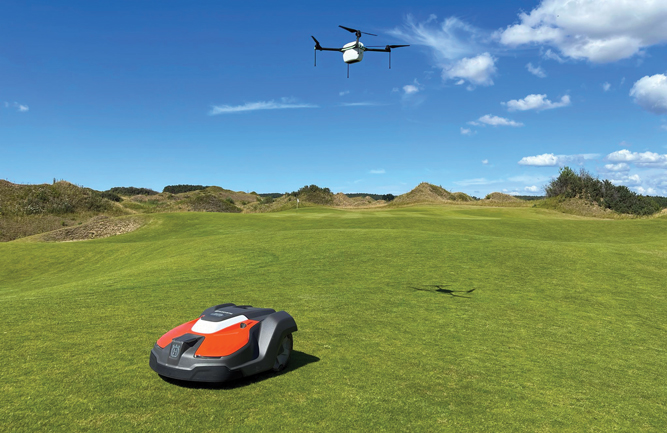
With an influx of robotics in golf enhancements in GPS guidance have become more important as superintendents navigate the ecosystem. (Photo courtesy of: Greensight/Husqvarna)
In addition to the people who make up his maintenance staff, Ehrentraut and Blackhawk employ a fleet of 30 of Husqvarna’s 550 EPOS Automowers.
“We invested the money into a whole fleet and started cutting fairways with them,” he says. “Right now, they’re cutting at half an inch on our fairways. We’re also looking to start moving into some rough areas as well to save a bit on the labor that we had going toward cutting those areas. We’ve also started going more into detail work to see what we can get done with (the mowers.)”
Ehrentraut’s 550s utilize EPOS (Exact Positioning Operating System), which allows him to set a boundary for the mower to work within. After his boundaries are set, Ehrentraut says the mower will operate within them and mow the most efficient route.
Ehrentraut says he understands the hesitation of some in the industry toward robotic, GPS-guided mowers. But, he says, it’s more than likely a matter of when, not if, they become a part of a superintendent’s daily life — so now is the time to hop on the train.
“For me, it’s, it’s always been the future. We either have to embrace it or not because it’s the way we have to go,” he says. “I want to see these things work because it’s the only way we’re going to get some of this stuff done in the future.”

Ken Rost
Frost
CEO
The advancement I’m most excited about is, that when you have a sprayer that’s able to execute prescription applications, you have to generate a prescription map to give the sprayer for it to execute it. In the past, boundaries and information would all be collected and handed off to what would be considered a GIS (geographical information systems) professional who is familiar with the program and would take all the information and generate a map for the golf course superintendent.
There have been some attempts and failures in the industry to generate a program that anyone could use, and it’s been a problem. But the folks at GreenKeeper have developed just exactly that. It just so happens that there’s other important data information that the GreenKeeper program provides, but now anybody can make these maps using GreenKeeper. They’re calling it CIS or Course Information System. Frost has no stake in the game with GreenKeeper other than that, we kind of helped them develop the program. I’m super excited for it because it gives the superintendent the power to make any edits, any changes, anything that he needs to do with his prescription maps he can do now very simply and very quickly.
David Anderson
John Deere
Product Manager
By incorporating GPS technology in daily practices, superintendents can save time and money. Improvements with receivers continuously provide enhanced accuracy and precision for critical operations, such as applications.
Additional improvements also unlock their abilities to receive satellite-based Real Time Kinematic corrections, which will eliminate the need for additional, on-site infrastructure, commonly referred to as a “base station.” This accuracy allows users to be more efficient and sustainable in their practices. Users can utilize GPS technology for lower accuracy needs like machine tracking.
As technology continues to advance, the adoption of that technology continues to advance as well. As we see assistant superintendents who are coming up and becoming superintendents, they grew up with phones in their hands and instant access to data and information. They’re the ones who are driving this (technology) and want to know more about their operations at an instant glance — and be able to change and adjust on the move.

Jason VanBuskirk (Photo: GreenSight)
GreenSight
Jason Van Buskirk
Vice President of Sales
Our mapping and what we’re able to offer the customer base as an actual map feature has become more refined to where we have the capacity to map a golf course and specify the number of mowers you’ll need. We can integrate everything through TurfCloud so that the customer is left with an exact number of how many units they will need.
It’s no longer “We think this might fit for what you want.” Instead of having customers say, “What do you think? I’ll only need a couple of units here on the driving range,” we can tell them that, if they want to do this at night, they’re going to need 10 units. Whereas before you might think, “Well, I’ve got six acres of grass and three units, I’ll be fine.”
Now we know that if you have six acres, you better believe every bit of six units is going out there, if not more. In addition to that, we are continuing to expand our automower footprint and improving the Turf Cloud platform to have more features for the user. In 2024 we’re adding more and more customers to the base where it’s not just like a one- or two-mower type of operation. We’re seeing more and more courses say, “We’re ready to go with 10 units, we’re ready to go with a rough solution or a fairway solution,” and we can provide that.


