Golf course soil-moisture mapping
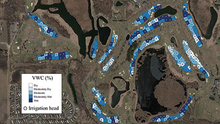
Final map after completing the soil-moisture mapping protocol, where irrigation classes have been assigned to individual irrigation heads based on surrounding soil-moisture values (percentage volumetric water content). (Photo: Chase Straw)
Golf course superintendents often irrigate fairways based on a feeling. However, using objective data to create soil-moisture maps of golf course fairways — as well as taking advantage of valve-in-head control — can significantly reduce water consumption by programming irrigation systems to match soil-moisture variability.
In an effort to increase the use of soil-moisture maps for improved irrigation decisions, and to allow superintendents a low-risk option to get their feet in the door with mapping technologies, the University of Minnesota and the Minnesota Golf Course Superintendents Association (MGCSA) have collaborated to create a practical fairway soil-moisture mapping initiative.
A detailed protocol outlines step-by-step instructions to collect geo-referenced soil-moisture data with a GPS-equipped soil-moisture meter, which can create fairway soil-moisture maps and irrigation management zones with free mapping software.
A system also is being put in place in which those who don’t have a GPS-equipped soil-moisture meter can borrow a device owned by the MGCSA or a fellow member. The MGCSA anticipates several positive outcomes from this initiative, such as water conservation, reduced water cost, legislative appreciation, state agency acknowledgement with potential long-term impact on water priorities and added MGCSA membership value.
The protocol is available to everyone and is applicable at any golf course. You may download it for free here.
Thank you to the Minnesota Golf Course Superintendents Association for its support developing the soil-moisture mapping protocol.
Subscribe to Golfdom

If you enjoyed this article, subscribe to Golfdom to receive more articles just like it.