
Drones, data and turf maintenance
 The old adage “A picture is worth a thousand words” is a refrain to which golf course superintendents subscribe. Photographs help turfgrass managers explain agronomic and maintenance programs to members and sell renovation and capital improvement projects to boards of directors. A smartphone snapshot now is a powerful and ubiquitous communication tool of the trade.
Now imagine the impact when the ante is upped in the visual communication game from hand-held pictures taken with a cell phone to detailed visuals taken by drones 200 feet high in the sky that can also provide a wealth of useful data.
Drones, once viewed by many as simply a recreational toy and a way to take bird’s-eye- view pictures of a course — mainly for marketing purposes to share on YouTube, social media or a website — now are a useful agronomic aid and money-saving technology that provides everything from a clearer picture of where the divots occur most frequently to areas that are suffering from a lack of irrigation.
Mark Prieur, golf course superintendent at Trafalgar Golf and Country Club in Milton, Ontario, just west of Toronto, bought a drone last year. He finds new uses for this piece of technology every day, from taking aerial shots showing frost on the course and tweeting them so members know why there was a delay in tee times, to helping him train employees by showing proper techniques from a new, unique angle.
“It’s just another tool,” Prieur says. “When you get it, you start using it for things you never thought you would use it for. I recently used it for training purposes to show my staff a bunker (photo) taken with the drone and explaining that this is what a properly raked bunker is expected to look like when it’s done.”
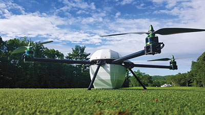
The data that drones give superintendents like Prieur is limitless, thanks to innovative companies moving the technology forward. One such company, GreenSight Agronomics, provides drone-enabled golf course services that give superintendents valuable information to help them manage their staff more effectively, reduce water usage, optimize fertilizer use and avoid costly pest or fungal damage while maximizing a course’s quality and playability.
“We started in 2015 with one-time surveys for golf courses, giving them a map of their course much better than what you would get from Google,” explains Justin McClellan, GreenSight’s chief marketing officer. “That was our beginnings. We quickly realized there was a need and an interest for this high-resolution imagery of the turf.”
“It’s just another tool,” Prieur says. “When you get it, you start using it for things you never thought you would use it for.“
All of the principals in the company have backgrounds in military drone systems using custom sensors. They figured they could use their expertise in drone technology to put together an interesting thermal camera sensor package that could read and measure the moisture levels in turf over an entire golf course. “We also realized we could use a multi-spectral camera to start looking for turfgrass diseases and pests,” McClellan adds.
New eyes
In April 2015, GreenSight added John Kaminski, Ph.D., director of the golf course turfgrass management program at Penn State University, to its team as chief agronomy officer. Kaminski sees many uses for this new technology, from being able to show shade patterns on fairways to seeing and identifying other troublesome patterns on the course before they become issues.
The automated drone technology developed by GreenSight can scan every inch of a course multiple times a week. Its custom multispectral camera captures five times the data of a typical camera and allows superintendents to detect evidence of pest and pathogens before they become visible to the naked eye. The thermal cameras also measure the temperature of all of the course’s turf.
After these scans are complete, the drone lands on its base station and automatically is recharged while the image data is downloaded. The extensive data is then processed by GreenSight’s proprietary analysis software. The software scans the multispectral image data for evidence of pests or pathogens and tracks daily changes. The temperature data is analyzed and used to develop a soil-moisture map of the course. Areas that are too dry or too wet are flagged before turf health begins to deteriorate.
After each flight survey, GreenSight’s system automatically sends the user an e-mail or text message report based on the scans to let superintendents know what issues are happening and where. Superintendents also can compare today’s imagery to last week’s, last month’s or last year’s with an app or website.
“We offer a complete system: our camera/drone and the assembly and installation of the drone that is off-the-shelf technology, but built around our camera,” McClellan explains. “We include software that puts all the images together. With daily flights we can see what changed from yesterday to today. Instead of just 100 acres of photos, our software can analyze for you detailed data, like here are the 20 acres on the course where we saw something change, the 10 places we saw the course drier and the 10 places we saw the beginnings of a pest infection. We hope to save superintendents time, not give them too much data that they don’t know what to do with.”
GreenSight is ready to roll out to courses in Florida and Arizona this fall a subscription-based service and app that measures soil moisture via thermal images that will tell golf course managers the percentage of moisture in their soil. “For example, that could be a very powerful tool for someone looking at installing a new irrigation system where they have independently controlled sprinkler heads,” McClellan says. “Superintendents will be able to see, on a daily basis, areas that are drying out or receiving too much water, and can easily pinpoint issues with the irrigation system, like leaks.”
For Kaminski, how companies such as GreenSights integrate and share the data once it’s collected is the key to the technology reaching its full potential. “With all that data being collected there is a need for sophisticated reporting and analysis,” he explains. “A superintendent won’t get the full benefit of this tool without data interpretation and integration between systems like golf carts, labor tracking and GPS sprayers. Without this cooperation, you’ll risk having an overwhelming amount of data that will never be useful.”
Trial by the Pacific Ocean
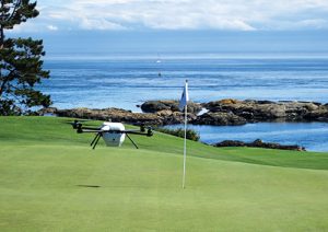
Paul Robertson is one of GreenSight’s first superintendent customers, and he currently is beta testing their product. The links superintendent at Victoria Golf Club in Oak Bay, British Columbia, Robertson gives credit to his assistant, who first saw mention of the technology on Twitter. Robertson immediately contacted GreenSight to ask how his club could get involved in using its equipment.
“I really believed in the technology,” he explains. “They were good to commit to us being one of the first test sites. The rest is history.”
“Superintendents will be able to see, on a daily basis, areas that are drying out or receiving too much water,” says McClellan.
This past July, GreenSight’s team arrived at the historic club, which was founded in 1893, to set up an antenna on the roof of Robertson’s maintenance shop and install other components that communicate constantly with the drone. Robertson initially hoped they could fly the drone as high as 500 feet, but because their club is situated on a point and an outward piece of property near the ocean is in airspace frequented by floatplanes and helicopters, Transport Canada approved a flight certificate to fly to a maximum of 200 feet.
The drone at Victoria GC currently flies from 5 a.m. to 8 a.m. “I wanted to create our baseline images of the golf course in the morning,” Robertson says. “Hopefully, we will eventually have a noon flight too, so our irrigation technicians can see where we started and where we finished to extrapolate some irrigation data from those two different time-stamped images.”
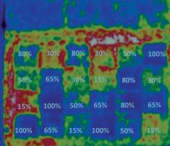
After one month into their trial, Robertson and his staff already are reaping benefits from the wealth of data provided by the drone. “The main reason we wanted to use this technology was to get a better idea on water management,” he says. “I can already see other (uses) for it. You can take the infrared images and eventually we can add a temperature camera that will allow us to collate that data into some sort of soil moisture amount. Over time, we can take what we see in infrared and transfer that into percent soil moisture so we can eliminate or reduce the need for people out on the course with hand-held devices collecting soil moisture data.”
Last year, Robertson had two to three students out in the morning probing fairways and two additional staff members probing greens. The data they collected dictated how much water they were going to put out on the golf course at night or how much hand watering they needed to do. “These readings, though, are only as good as the amount of points of data you take,” Robertson explains. “For example, on a green I would take anywhere between nine to 12 data points, and that gives you just a representative sample. These infrared images are right down to the millimeter/inch, so they give you precise control.
“Over time we are hoping to see early diagnosis of disease by seeing different changes in the temperature in the photos and a different reflection of the green light,” he adds. “That might be an indication of a disease like anthracnose or Pythium; You just see the turfgrass reacting differently to a stress in an area.”
What Robertson mainly has seen in the first month of use is compaction. “You really notice the areas of compaction on the golf course,” he says. “The greens just shine bright red. We hope as we go to aerate this fall (that) we will see a change to this compaction. That was our first big clue there will be other uses for this technology.”
Robertson also sees the technology helping with his tree management program, with a better method of identifying trees with health issues. The club already spent a lot of money to get an arborist to inventory all of the trees on the property and label them from 1 (least concern) to 3 (most hazardous). “I’m hoping that this infrared image will be able to show those trees looking differently, reflecting light differently and further pinpoint our management programs,” he says.
Finally, beyond saving money on water, the technology also aims to help superintendents identify signs of diseases much earlier and zero in on the problem areas, which should lead to a reduction in pesticides and fungicides. “We might get to a point where we can look at areas of the golf course and say, ‘That turf needs more nitrogen based on the reflection of the green light,’” Robertson says. “I’m really looking forward to reducing pesticides by looking at the greens and only having to spray those areas that are hot and showing signs of stress, indicating they might have a disease forthcoming.”
Cost savings can come, Robertson says, between the labor redistribution and reduction in watering to lowering the pesticide budget, which he figures could be as much as 10 percent if he can pinpoint diseases earlier and with more accuracy.
“Last year I spent $15,000 on hand probing, but what happens if I replace that labor with the drone?” he asks. “I wouldn’t eliminate those employees, but I would put them on the golf course doing other things like hand watering, bunker maintenance, fly mowing, etc. I just wouldn’t have them stuck on the end of a probe.
“The sky truly is the limit,” he concludes. “There has been a lot of game-changing technology in the golf industry in the last 20 years. I think most courses will have this technology in the next five years, even if it is just for promotional purposes.”
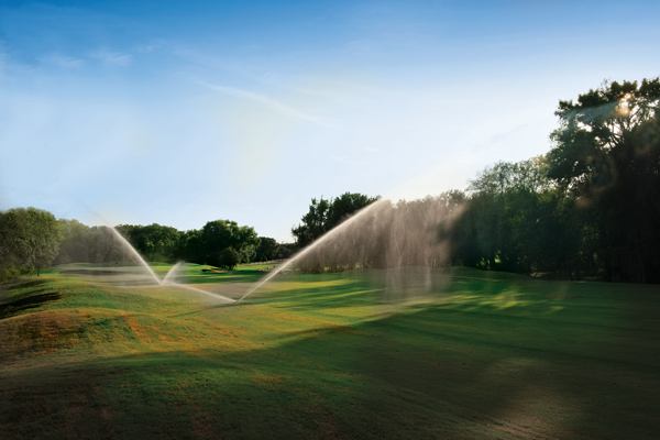
Photos: Greensight agronomics
Subscribe to Golfdom

If you enjoyed this article, subscribe to Golfdom to receive more articles just like it.
1 Comment on "Drones, data and turf maintenance"
Trackback | Comments RSS Feed
Inbound Links