Help from above: How can drones benefit your course?
A new era is here for small, low-cost drone photography and mapping
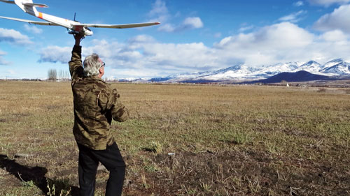
A small fixed-wing drone with two attached cameras is hand launched. It is then switched over to autonomous flight at a specific altitude.
You’ve probably seen a few up in the air. But did you ever wonder what drones could be doing to benefit your course beyond the photos or video?
Over the last 5 years a new era in precision agriculture has arrived, and it includes golf courses. What used to take a pilot, a plane or helicopter, a cameraman, a film processor, a cartographer/GIS guy and about 8 weeks can now essentially be done by one person with some skill and a few hours.
Aerial mapping isn’t new, but small, fixed-wing or rotor drones with the capabilities for low-cost mapping and NIR imaging is.
While we don’t suggest that you go buy a drone and do it yourself just yet, drone mapping should be available soon, and it will be nearly real-time. The images a drone takes are processed into geo-referenced 2D orthomosaics and 3D digital elevation models. Depending on the altitude and resolution you desire, it could take these images less than a day to be on your laptop, in the hands of your GIS guy, loaded on your Google Earth app or sent to the golf course administrator.
These images are easily laid out by KMZ file on Google Earth, which is free. Google Earth is extremely easy to use. Every superintendent and administrator should have it on his or her computer.
Gathering the images
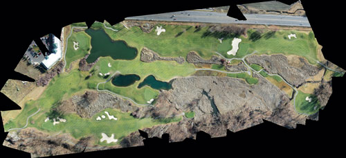
An orthomosaic showing a part of a golf course used in a wetland study.
On the right is an example of an orthomosaic. It was created for a course in Utah and generated from about a 20-minute flight plan using about 65 images processed together.
The images for this orthomosaic were taken from a small fixed-wing platform with an autopilot that is flown by a computer from an easily generated flight plan. Having an autopilot and inertial measurement unit (IMU) fly the drone keeps the aerial platform and the attached camera horizontal to the ground, which makes post-flight processing much easier.
Two types of drones can map courses: fixed-wing drones and rotor drones. Small, fixed-wing drones (planes) fly from a mission flight plan via their autopilot and can easily cover the needed area and adjust when the drone is in flight. Fixed-wing drones are extremely stable and cover a lot of area fast. Fixed-wings require some altitude to fly safely, so the resolution quality of the images is slightly less (2-3cm per pixel) than that of a rotor drone, which achieves better resolution because it’s easier to fly at a lower altitude (< 2cm resolution per pixel)
Rotor drones fly with an IMU and GPS and can contain an autopilot and also are flown via a flight plan. Rotor drones provide a stable platform and provide extreme resolution, but they don’t cover larger areas as well as fixed-wings because flight time is limited by battery power. Fixed wings also move faster.
Low-cost mapping
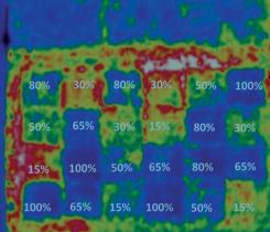
With the price of near-infrared (NIR) technology dropping and sensor size getting smaller, NIR is entering the era of low-cost drone mapping as well. NIR allows you to see plant stress before you can see it with the naked eye.
Post-processed image creates a KMZ file that can be downloaded and opened on Google Earth and which automatically georectifies itself and covers the imagery at that location.
Imagine a drone that flies over your course every couple of weeks. It contains low-cost cameras capable of producing datasets from NIR and RGB bands that allow you to obtain Normalized Difference Vegetation Index (NDVI) calculations to assess moisture content of the soil and areas that detail plant stress. This can all be processed and back to you in the same day in order to make the necessary adjustments. Those images allow you to determine whether your irrigation system, disease control program and fertilizers are working together correctly and covering the areas you want.
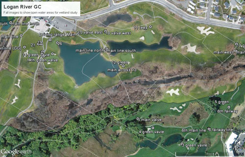
The image to the right is another example of images showing a slightly larger area of the course with the attached valve layouts. Again mapped with a fixed-wing drone, it was flown in the fall after leaves had fallen so areas of cattails, open water and the river could be seen.
This map originally was used to show vegetation and wetland management boundaries for an ongoing environmental study. Wetland studies and environmental impact statements are another important area where drones can help course managers and administrators manage within their specific guidelines. Using Google Earth, orthomosaics that are georectified can monitor wetland areas, open water and even certain plant species (specifically with the spread of phragmites in the West and the amount of water they absorb.)
Once a drone is switched over to autonomous flight, the auto-pilot provides straight and level flight at a specific altitude, which aids in image processing and obtaining a specific resolution.
The future of drones for precision course management depends on what the FAA rules is allowable later this year. The FAA is currently allowing some companies to do precision agriculture mapping, and more will follow. Golf courses not located in highly populated areas and away from airports and flight paths stand a high chance of being able to use drones for course management in the near future.
Chris Thomas owns Aerial Pursuit Mapping, specializing in small area, high resolution, geo-rectified UAV mapping. For more information visit aerialpursuit.org. Thanks to Randy Oldham, Miguel Leonardo and Rio Thomas for contributing to this article.
Photos by: iStock.com/Mehmet Hilmi Barcin | Chris Thomas
Subscribe to Golfdom

If you enjoyed this article, subscribe to Golfdom to receive more articles just like it.